AerEO’s core promise: every job writes GeoTIFFs aligned to the same Major TOM grid, plus an artifacts.parquet catalog. Outputs from different dates — and different sensors — therefore merge directly into ML-ready tensors, with no manual reprojection and no alignment code.
This chapter proves it end to end:
Run three jobs over the same AOI and grid: Sentinel-2 NDVI at two date ranges, plus a Sentinel-1 SAR scene.
Join their catalogs by
grid_cell.Fill the gaps: mosaic multiple scenes per cell so partial footprints become full coverage.
Stack the rasters into a single multi-sensor tensor:
ndvi_t1,ndvi_t2,vv,vhchannels.Save the merged Major TOM index: one GeoParquet row per grid cell, all constellations in one table — then load a single shared cell back from it.
Environment setup
The first cell installs AerEO and any required plugins. If you are reading the rendered book or running on Binder, where the environment is already prepared, pip will report that the requirements are satisfied and skip the download.
# Install AerEO and any required plugins for this notebook (Google Colab)
!pip install -q "aereo[viz,pc]"
Config files used in this chapter
The next cell downloads the AOI plus three job configs: job_sentinel2-ndvi.yaml (Sentinel-2 red+nir with the ndvi built-in as preprocess), job_sentinel2.yaml which it inherits from, and job_sentinel1.yaml (Sentinel-1 GRD vv/vh from Planetary Computer, the same setup as the previous chapter). All three jobs reuse these configs unchanged — only the date range, job name, and output URI vary, via Hydra overrides. The grid (grid_dist: 10_000) and AOI stay identical, which is exactly what makes the outputs joinable.
# Download config files and AOIs from the GitHub repository so this
# notebook can run outside the repo (e.g. Google Colab).
import os
import urllib.request

GITHUB_RAW = "https://raw.githubusercontent.com/frandorr/aereo/main"

os.makedirs("config/aoi", exist_ok=True)

# Config files (job_sentinel2-ndvi.yaml inherits from job_sentinel2.yaml)
for name in ["job_sentinel2.yaml", "job_sentinel2-ndvi.yaml", "job_sentinel1.yaml"]:
    urllib.request.urlretrieve(
        f"{GITHUB_RAW}/examples/config/{name}",
        f"config/{name}",
    )

# AOI files
urllib.request.urlretrieve(
    f"{GITHUB_RAW}/examples/config/aoi/chocon.geojson",
    "config/aoi/chocon.geojson",
)
Loading the three jobs
ExtractionJob.load_from_config() accepts Hydra overrides in dot notation, so we derive all three jobs from two YAML files without editing anything. The SAR scene comes from a different date than the optical ones — the join is spatial, not temporal: same grid_cell, same pixels on the ground.
from aereo.cache import TaskResultCache
from aereo.executors import LocalExecutor
from aereo.pipeline import ExtractionJob

def load_ndvi_job(name: str, start: str, end: str) -> ExtractionJob:
    return ExtractionJob.load_from_config(
        config_dir="config",
        config_name="job_sentinel2-ndvi",
        overrides=[
            f"name={name}",
            f"output_uri=/tmp/aereo_ml/{name}",
            f"search.start_datetime={start}",
            f"search.end_datetime={end}",
        ],
    )

job_t1 = load_ndvi_job("ndvi_t1", "2024-01-01T00:00:00Z", "2024-01-03T23:59:59Z")
job_t2 = load_ndvi_job("ndvi_t2", "2024-01-08T00:00:00Z", "2024-01-20T23:59:59Z")

job_s1 = ExtractionJob.load_from_config(
    config_dir="config",
    config_name="job_sentinel1",
    overrides=["name=s1", "output_uri=/tmp/aereo_ml/s1"],
)
Running the extractions
Each job runs the standard pipeline (read -> preprocess -> reproject -> write) through a shared LocalExecutor, and finishes by writing its own artifacts.parquet catalog — one row per Major TOM grid cell.
local_exec = LocalExecutor(workers=-1, use_threads=True, cache=TaskResultCache())

def run(job: ExtractionJob) -> str:
    assets = job.search()
    tasks = job.build_tasks(assets)
    artifacts = job.execute(tasks, executor=local_exec)
    catalog = job.write_catalog(artifacts)
    print(f"{job.name}: {len(artifacts)} artifacts -> {catalog}")
    return catalog

catalog_t1 = run(job_t1)
2026-07-27 12:39:44 [info ] search_called provider=search_stac
2026-07-27 12:39:47 [info ] build_tasks_start assets=4 builder=build_grouped_tasks
2026-07-27 12:39:47 [info ] execute_start executor=LocalExecutor task_count=2
ndvi_t1: 14 artifacts -> /tmp/aereo_ml/ndvi_t1/artifacts.parquet
The second optical date and the Sentinel-1 scene run identically:
catalog_t2 = run(job_t2)2026-07-27 12:39:47 [info ] search_called provider=search_stac
2026-07-27 12:39:48 [info ] build_tasks_start assets=16 builder=build_grouped_tasks
2026-07-27 12:39:48 [info ] execute_start executor=LocalExecutor task_count=8
ndvi_t2: 56 artifacts -> /tmp/aereo_ml/ndvi_t2/artifacts.parquet
catalog_s1 = run(job_s1)2026-07-27 12:39:49 [info ] search_called provider=search_stac
2026-07-27 12:39:51 [info ] build_tasks_start assets=4 builder=build_grouped_tasks
2026-07-27 12:39:51 [info ] execute_start executor=LocalExecutor task_count=2
/home/fran/repos/aereo/.venv/lib/python3.13/site-packages/pydantic/_internal/_validate_call.py:137: UserWarning: assets has no 'crs' column; assuming all assets share the same native CRS. Mixed-CRS assets in one task may fail or produce incorrect results.
  res = self.__pydantic_validator__.validate_python(pydantic_core.ArgsKwargs(args, kwargs))
s1: 20 artifacts -> /tmp/aereo_ml/s1/artifacts.parquet
Joining the catalogs by grid_cell
Each artifacts.parquet row is one (grid cell, scene) pair. Because all three jobs used the same grid_dist, the same grid_cell id refers to the same pixels on the ground in every run — optical or SAR, the join key is just the cell id.
One thing to notice: rows are not files. These jobs use only a Reader and a Writer (no Reprojector stage — fine here because Sentinel-1 GRD and Sentinel-2 are already in UTM), so each task writes one raster for the whole AOI and every overlapping grid cell references it. With a Reprojector (reproject_mode="grid"), each cell becomes its own artifact instead. Both layouts are valid; the catalog keeps the mapping either way.
The practical consequence: to get the pixels of one cell you don’t open a cell-sized file — you window-read the cell from the shared raster. And the window to use is the cell’s GeoBox — see the code below.
import geopandas as gpd
import pandas as pd
import rasterio

from aereo.grid import GridCell

cat_t1 = gpd.read_parquet(catalog_t1).assign(slot="ndvi_t1")
cat_t2 = gpd.read_parquet(catalog_t2).assign(slot="ndvi_t2")
cat_s1 = gpd.read_parquet(catalog_s1).assign(slot="s1")
cat = pd.concat([cat_t1, cat_t2, cat_s1], ignore_index=True)

# Keep only grid cells observed by ALL THREE jobs.
counts = cat.groupby("grid_cell")["slot"].nunique()
common_cells = sorted(counts[counts == 3].index)
samples = cat[cat.grid_cell.isin(common_cells)]

print(f"{len(common_cells)} grid cells observed by all three jobs")
print(f"{len(samples)} catalog rows reference only {samples.uri.nunique()} unique GeoTIFFs\n")
print("Scenes per (grid cell, slot):")
print(samples.groupby(["grid_cell", "slot"]).size().unstack(fill_value=0))

# The extraction window for each cell: GridCell.to_geobox, the same object
# AerEO uses in reproject_mode='grid'. Snapped centre + fixed size
# (grid_dist * (1 + margin)) -> EVERY cell gets the exact same pixel shape.
def geobox_bounds(cell_id: str, resolution: float = 10, margin: float = 10):
    r = samples[samples.grid_cell == cell_id].iloc[0]
    cell = GridCell(id=r.grid_cell, d=r.grid_dist, cell_geometry=r.cell_geometry)
    bb = cell.to_geobox(resolution=resolution, margin=margin).boundingbox
    return (bb.left, bb.bottom, bb.right, bb.top)

cell_bounds = {c: geobox_bounds(c) for c in common_cells}
side = (cell_bounds[common_cells[0]][2] - cell_bounds[common_cells[0]][0]) / 10
print(f"\nEvery cell window: {side:.0f} x {side:.0f} pixels at 10 m (11 km with 10% margin)")
10 grid cells observed by all three jobs
90 catalog rows reference only 12 unique GeoTIFFs
Scenes per (grid cell, slot):
slot ndvi_t1 ndvi_t2 s1
grid_cell
437D_592L 1 4 2
437D_593L 1 4 2
437D_594L 2 8 2
437D_595L 2 8 2
438D_592L 1 4 2
438D_593L 1 4 2
438D_594L 2 8 2
439D_591L 1 4 2
439D_592L 1 4 2
439D_593L 2 8 2
Every cell window: 1100 x 1100 pixels at 10 m (11 km with 10% margin)
Filling the gaps: mosaicking scenes per cell
Why are there holes? Within a cell’s window, pixels are nodata wherever the source scene’s footprint doesn’t cover the cell. A single Sentinel-2 tile rarely covers a whole cell, and a Sentinel-1 swath edge cuts straight through the AOI. Clouds punch additional holes in optical data.
The two levers you have:
More dates. A wider search window extracts more scenes per cell. Different acquisition geometries overlap differently, so their union covers more ground. (Caveat: at this AOI every Sentinel-1 pass in the archive uses the same relative orbit, so extra S1 dates repeat the same footprint — a temporal mean still helps by reducing speckle, and the two scene segments of one pass do extend coverage along-track. Check
sat:relative_orbitif you rely on this for coverage.)Mosaic per cell. Window every scene of a cell to the cell’s GeoBox and combine pixel-wise. Here we use a mean of the valid pixels at each location (
nanmean); a median is more robust to clouds, and “latest valid wins” is common for near-real-time products.
Why the GeoBox and not cell_utm_footprint? The raw UTM footprint is a rotated polygon, so its bounding box has a slightly different area for every cell — windows cut from it end up with mismatched shapes. GridCell.to_geobox instead snaps the centre to the alignment grid and builds a box of fixed metres (grid_dist × (1 + margin)) with integer pixels: every cell, every sensor, exactly the same shape. This is the same GeoBox AerEO builds internally in reproject_mode="grid".
rasterio.merge.merge with the GeoBox bounds reads only the window that intersects the cell (the full-AOI raster never loads entirely) and cuts it to that exact grid.
Optical refinement: for production optical mosaics, mask clouds before mosaicking — AerEO’s built-in
qa_maskprocessor (used with Sentinel-2’s SCL band) plugs into the job config as apreprocessstep.
import warnings

import numpy as np
from rasterio.merge import merge

def mosaic(rows: pd.DataFrame, bounds) -> np.ndarray:
    """Mosaic all scenes of one (grid_cell, slot), windowed to the cell's GeoBox."""
    aligned = []
    for uri in dict.fromkeys(rows.uri):  # one shared tif per scene
        with rasterio.open(uri) as src:
            # merge() with explicit bounds reads only the cell window and
            # cuts it to the pixel grid; masked=True maps nodata -> NaN.
            arr, _ = merge([src], bounds=bounds, masked=True)
            aligned.append(np.asarray(arr.filled(np.nan), dtype="float32"))
    with warnings.catch_warnings():
        warnings.simplefilter("ignore", RuntimeWarning)  # all-NaN pixels stay NaN
        return np.nanmean(np.stack(aligned), axis=0)

SLOTS = ["ndvi_t1", "ndvi_t2", "s1"]
CHANNELS = ["ndvi_t1", "ndvi_t2", "vv", "vh"]

def read_cell(cell_id: str) -> np.ndarray:
    """Mosaic all slots of one grid cell -> (channel, y, x), cell-sized."""
    cell = samples[samples.grid_cell == cell_id]
    bounds = cell_bounds[cell_id]
    mosaics = [mosaic(cell[cell.slot == slot], bounds) for slot in SLOTS]
    return np.concatenate(mosaics, axis=0)  # shapes match exactly, thanks to the GeoBox

data = np.stack([read_cell(c) for c in common_cells])  # (sample, channel, y, x)
print(f"tensor: {data.shape}  # (sample, channel, y, x) — every cell exactly the same shape")
tensor: (10, 4, 1100, 1100) # (sample, channel, y, x) — every cell exactly the same shape
Before and after
Same cell and slot: the best single scene vs the mosaic of all scenes, both windowed to the cell’s GeoBox. The wedge-shaped nodata areas are filled by the other dates — and what is left as NaN genuinely has no observations (outside every footprint).
import matplotlib.pyplot as plt

def valid_frac(arr: np.ndarray) -> float:
    return float(np.isfinite(arr).mean())

def single_scene(uri: str, bounds) -> np.ndarray:
    """One scene windowed to the cell GeoBox -> (bands, y, x)."""
    with rasterio.open(uri) as src:
        arr, _ = merge([src], bounds=bounds, masked=True)
        return np.asarray(arr.filled(np.nan), dtype="float32")

# Pick the (cell, slot) where mosaicking gained the most coverage.
gains = {}
for cell_id in common_cells:
    cell = samples[samples.grid_cell == cell_id]
    bounds = cell_bounds[cell_id]
    for slot in SLOTS:
        rows = cell[cell.slot == slot]
        uris = list(dict.fromkeys(rows.uri))
        if len(uris) < 2:
            continue
        best_single = max(valid_frac(single_scene(u, bounds)) for u in uris)
        gains[(cell_id, slot)] = valid_frac(mosaic(rows, bounds)) - best_single

cell_id, slot = max(gains, key=gains.get)
bounds = cell_bounds[cell_id]
rows = samples[(samples.grid_cell == cell_id) & (samples.slot == slot)]
uris = list(dict.fromkeys(rows.uri))
best_uri = max(uris, key=lambda u: valid_frac(single_scene(u, bounds)))
before = single_scene(best_uri, bounds)[0]
after = mosaic(rows, bounds)[0]

cmap = "RdYlGn" if slot.startswith("ndvi") else "gray"
if slot == "s1":  # dB for display, as in the final plot
    before = 10 * np.log10(np.clip(before, 1e-6, None))
    after = 10 * np.log10(np.clip(after, 1e-6, None))

fig, axes = plt.subplots(1, 2, figsize=(11, 5), constrained_layout=True)
for ax, arr, title in zip(axes, [before, after], ["best single scene", f"mosaic of {len(uris)} scenes"]):
    im = ax.imshow(arr, cmap=cmap, **({"vmin": -1, "vmax": 1} if cmap == "RdYlGn" else {}))
    ax.set_title(f"{cell_id} — {slot}\n{title} ({valid_frac(arr):.0%} valid)")
    ax.axis("off")
fig.colorbar(im, ax=axes, shrink=0.7)
plt.show()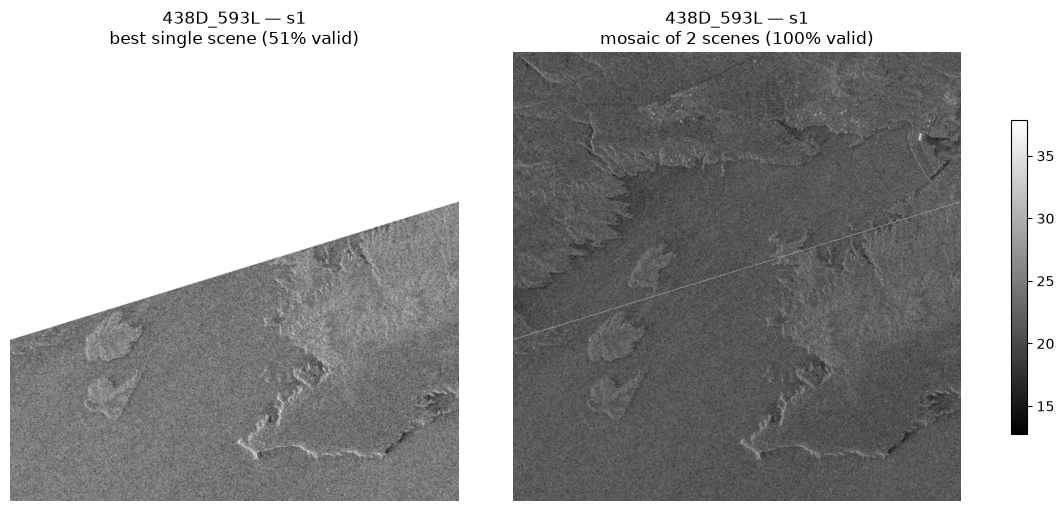
One multi-sensor tensor
The per-cell mosaics stack into the final xarray tensor: each sample is a grid cell with 4 channels — ndvi_t1, ndvi_t2 (1 band each) and vv, vh (from the 2-band Sentinel-1 raster). Every array here is cell-sized, windowed from the shared rasters — no full-AOI rasters in memory.
import xarray as xr

tensor = xr.DataArray(
    data,
    dims=("sample", "channel", "y", "x"),
    coords={"sample": common_cells, "channel": CHANNELS},
)
tensorThe deliverable: one Major TOM index for all constellations
The merged index is just the concatenation of the three artifact catalogs — no grouping, no compression. Like the Major-TOM Core datasets, it keeps one row per observation: a grid_cell appears once per scene and time slot, and rows are identified by their start_time/end_time. That keeps every observation addressable — you decide later whether to mosaic, stack a time series, or pick the latest.
Because all three catalogs share the same schema (grid_cell, start_time, uri, cell_geometry, …), merging is a plain concat. This is the table you hand to the rest of your stack: filter by cell or time, window-read the referenced rasters, and every row is guaranteed to reference the same pixels on the ground across sensors.
# The merged Major TOM index: one row per (grid cell, scene, slot).
# Repeated grid_cell values are intentional — identified by start/end time.
merged = (
    pd.concat([cat_t1, cat_t2, cat_s1], ignore_index=True)
    .sort_values(["grid_cell", "start_time"])
    .reset_index(drop=True)
)

index_path = "/tmp/aereo_ml/majortom_index.parquet"
merged.to_parquet(index_path)
print(f"Major TOM index written to {index_path}")
print(f"{len(merged)} rows, {merged.grid_cell.nunique()} unique cells, "
      f"{merged.uri.nunique()} unique rasters, "
      f"{merged.collection.nunique()} collections: {sorted(merged.collection.unique())}")

# Read it back: the merged, multi-constellation catalog.
gpd.read_parquet(index_path)[["grid_cell", "slot", "collection", "start_time", "uri"]].head(8)
Major TOM index written to /tmp/aereo_ml/majortom_index.parquet
90 rows, 10 unique cells, 12 unique rasters, 2 collections: ['sentinel-1-grd', 'sentinel-2-l2a']
Sanity check — same cell, three views
Mosaicked NDVI at t1 and t2 next to the mosaicked SAR vv backscatter (shown in dB for contrast), all windowed to the same grid cells. Rows are samples, columns are channels — the layout of a training batch. The reservoir is unambiguous in SAR (dark = smooth open water) even where optical is cloudy or ambiguous: the classic SAR+optical fusion motivation, delivered as aligned tensors.
n_show = min(4, len(common_cells))
fig, axes = plt.subplots(n_show, 3, figsize=(11, 3 * n_show), constrained_layout=True)
for i in range(n_show):
    for j, ch in enumerate(["ndvi_t1", "ndvi_t2", "vv"]):
        ax = axes[i, j]
        band = tensor.sel(sample=common_cells[i], channel=ch).values
        if ch == "vv":
            band = 10 * np.log10(np.clip(band, 1e-6, None))  # dB for display
            im = ax.imshow(band, cmap="gray")
        else:
            im = ax.imshow(band, cmap="RdYlGn", vmin=-1, vmax=1)
        ax.set_title(f"{common_cells[i]} — {ch}")
        ax.axis("off")
    fig.colorbar(im, ax=axes[i, :].tolist(), shrink=0.6)
plt.show()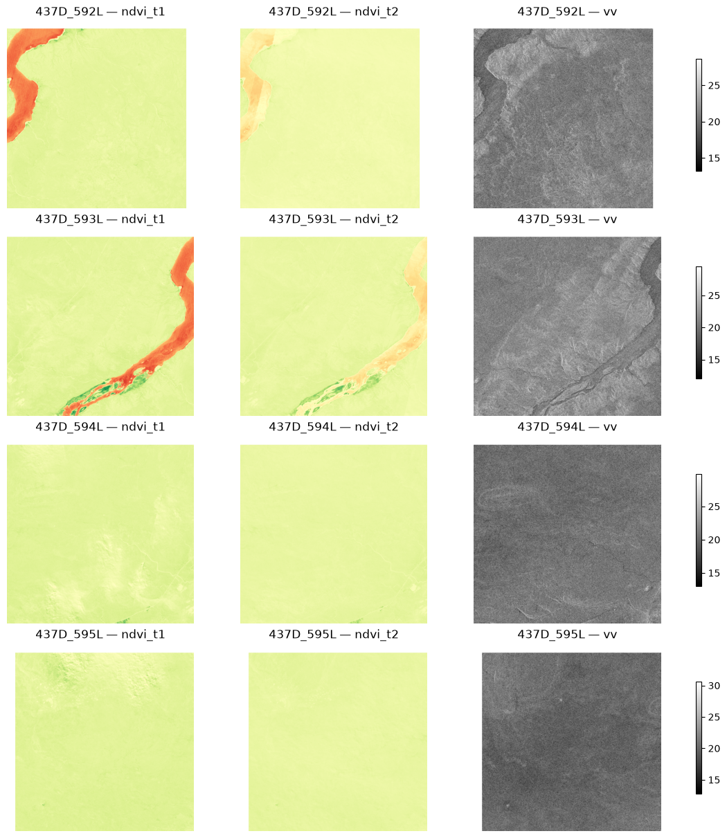
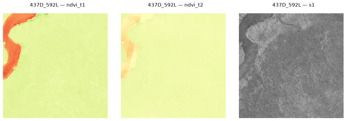
Loading a single cell from the index
Filter the index to one grid_cell and you get every observation of that cell across constellations and dates. Window-read each referenced raster with the cell’s GeoBox, mosaic per slot, done — the full-AOI GeoTIFFs are never loaded entirely.
cell_id = "437D_592L"  # pick any cell from the index
rows = merged[merged.grid_cell == cell_id]
bounds = cell_bounds[cell_id]

print(f"{len(rows)} index rows for cell {cell_id}:")
print(rows[["slot", "collection", "start_time"]].to_string(index=False))

def load_cell(rows: pd.DataFrame, bounds) -> dict[str, np.ndarray]:
    """Rebuild one cell's mosaicked channels from its index rows (windowed reads)."""
    out = {}
    for slot in SLOTS:
        aligned = []
        for uri in dict.fromkeys(rows[rows.slot == slot].uri):
            with rasterio.open(uri) as src:
                arr, _ = merge([src], bounds=bounds, masked=True)
                aligned.append(np.asarray(arr.filled(np.nan), dtype="float32"))
        with warnings.catch_warnings():
            warnings.simplefilter("ignore", RuntimeWarning)
            out[slot] = np.nanmean(np.stack(aligned), axis=0)
    return out

channels = load_cell(rows, bounds)
print("\n", {k: v.shape for k, v in channels.items()})  # cell-sized, not AOI-sized

fig, axes = plt.subplots(1, 3, figsize=(12, 4), constrained_layout=True)
views = [("ndvi_t1", "RdYlGn", (-1, 1)), ("ndvi_t2", "RdYlGn", (-1, 1)), ("s1", "gray", None)]
for ax, (slot, cmap, vminmax) in zip(axes, views):
    arr = channels[slot][0]
    if slot == "s1":
        arr = 10 * np.log10(np.clip(arr, 1e-6, None))  # vv in dB
    kwargs = {"vmin": vminmax[0], "vmax": vminmax[1]} if vminmax else {}
    ax.imshow(arr, cmap=cmap, **kwargs)
    ax.set_title(f"{cell_id} — {slot}")
    ax.axis("off")
plt.show()
7 index rows for cell 437D_592L:
slot collection start_time
ndvi_t1 sentinel-2-l2a 2024-01-02 14:33:47.691000
ndvi_t2 sentinel-2-l2a 2024-01-10 14:43:37.378000
ndvi_t2 sentinel-2-l2a 2024-01-12 14:33:45.063000
ndvi_t2 sentinel-2-l2a 2024-01-17 14:33:38.600000
ndvi_t2 sentinel-2-l2a 2024-01-20 14:43:34.277000
s1 sentinel-1-grd 2024-03-23 23:26:36.019841
s1 sentinel-1-grd 2024-03-23 23:27:01.019808
{'ndvi_t1': (1, 1100, 1100), 'ndvi_t2': (1, 1100, 1100), 's1': (2, 1100, 1100)}